
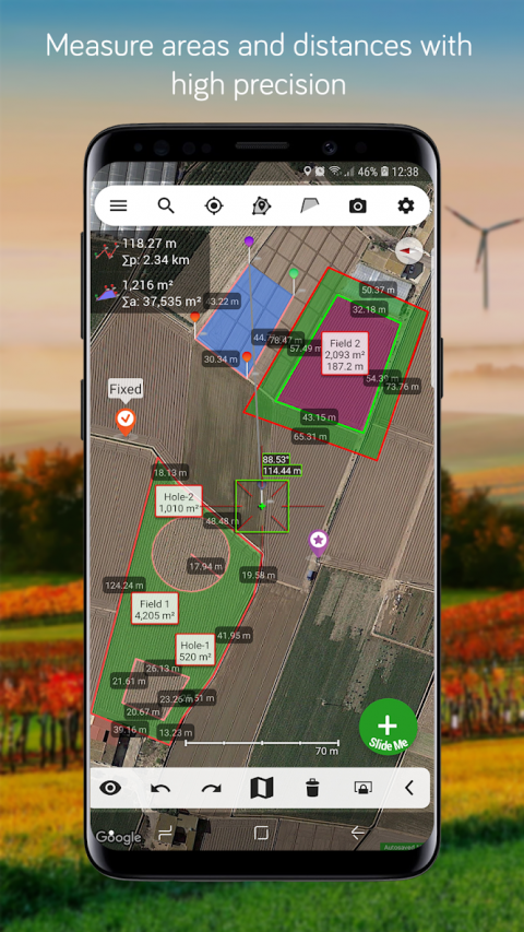
MeasureMapLiteletsyouquicklyandeasilydrawpolygonsandmeasuredistances,perimetersandareasoverMapswithlasersharpprecision.Iteventakesintoaccountthecurvatureoftheearth’ssurface.Useitforsmallareasorlarge,thenshareyourfindingsviaanysharingapponyourdevice.
Youmaybeanarchitect,asportsenthusiastorageographyhobbyist.Itdoesn'tmatterwhyyouhaveakeeninterestinaccuratedistances,itjustmattersthatyouhavethetoolstosatisfyyourneedtoknowthem.
That’swhatMeasureMapisfor,toputapowerful,portablemeasuringtoolrightinthepalmofyourhand.YourAndroiddevicecannowprovideyouwithtotallyprecisemeasurementsofanydistance,fromassmallasametertoasbigasthousandsofkilometersormiles,eventakingthecurvatureoftheearth’ssurfaceintoaccountwhenmeasuring.Itdoesallthat,fastandeffortlessly.
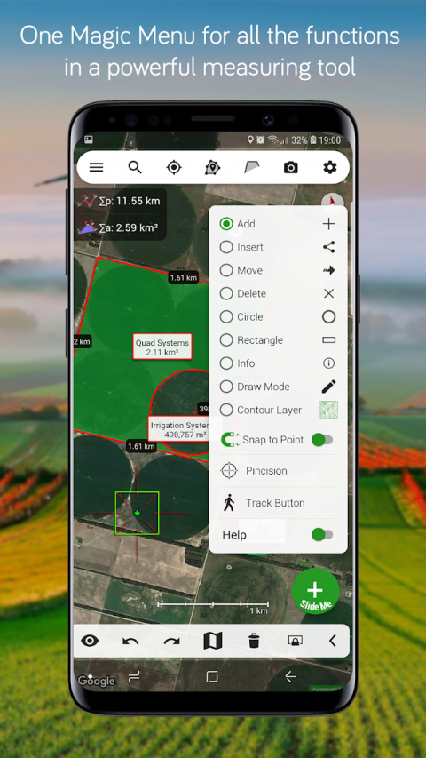
Youdon’tneedadegreetotakeadvantageofwhatMeasureMapoffers.Justdragthecross-hair,plunkpinsintomarktheareayouwantmeasuredand–boom!It’sdone.Easy,right?.The"Magic"buttonallowsyoutoinputpointsmoreeasilywithoutlosingit'sprofessionalaccuracy.
Theappmeasuresanydistance,route,orareayouwant,overMaps.Wanttocalculateyourdriveonthegolfcourse,ormaybefindoutthedistanceofthatmarathonyou’rethinkingofentering?Goahead.Needtoknowthesizeofaparcelofarablelandforyourcompany?Youcandothat,too.
TherestrictionsoftheLiteversionare:
*Youcanonlycreateonepolygonwithamaximumnumberof6pins.
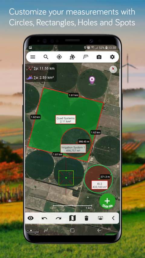
*Noshapes:Cannotcreateacirclenorarectangle.
*Noextramaps.
*NoTrackButton.
*OnlyloadsMMPfileformat.
*Ads.
CheckouttheimpressivefeaturesyougetinMeasureMap:
*ExtraMaps:UpgradetoMeasureMapProtobeabletopurchaseandviewothermapsources.
*Attractive,smooth,easynavigationanduse
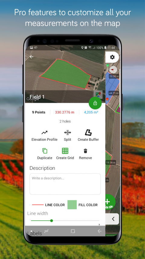
*ElevationProfileandaltitudeofaroute.
*DisplaysMapsView:Map,Satellite,hybridandterrain
*Operations:Add,deleteintermediatepins,insertbetweenpins,movepins,getinfo
*Undoandredooperationsasneeded
*Searchforcurrentlocation,text(villages,placesofinterest,etc.)oranareaorroute
*WorksforMetricandImperialmeasurements
*Lengthunits:meters,kilometers,feet,yards,miles,nauticalmiles,ken,ri,bù,lǐ,link,chain.
*Surfaceunits:squaremetersandkilometers,area,hectares,squarefoot,squareyards,squaremiles,acres,fanegas(Valencian,CastilianorColombian),tsubo,bu,so,lí,mǔ
*Abilitytoselectcolorandthicknessoftheperimeterline.
*Abilitytoselectthecolorandtransparencyoftheselectedarea.
*Exportingformats:MeasureMap,KML,CSV,Image(PNG)andPDF
*Exportandimportofsurfacesandroutesviayourstorageservicesaccount.
*Savetophotoalbum.
*DownloadsurfacesandroutesfromtheInternet.
Ifprecisemeasurementsareimportantorinterestingtoyou,thisistheappyouneed.Youwon’tfindonethatisbetter,moreaccurateandeasiertouse.
DownloadMeasureMapnowbutbewarned–measuringmaybecomeanobsession.
Show More

-
Measure Map Lite
9.2.0for Android
Blue Blink One